

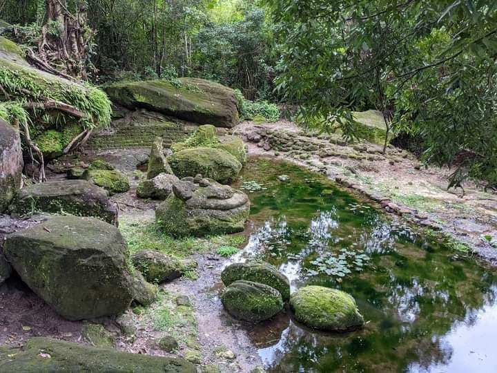
នៅរាជធានីមហេន្ទ្របព៌តភ្នំគូលែន ក្រៅពីចម្លាក់តាមប្រាសាទ ប្រព័ន្ធគ្រប់គ្រងទឹក និងកន្លែងយកថ្ម គឺភ្នំគូលែនមានចម្លាក់នៅលើផ្ទាំងថ្មធម្មជាតិ តាមពើង និងនៅតាមបាតស្ទឹងធម្មជាតិជាច្រើន។ ពើងឥសី គឺជារចនាសម្ព័ន្ធមួយដ៏សំខាន់សម្រាប់ការរៀបចំក្រុង ប្រព័ន្ធគ្រប់គ្រងទឹក ចម្លាក់លើផ្ទាំងថ្ម និងជំនឿសាសនានៅមហេន្ទ្របព៌ត។ តាមលោក Stern ឆ្នាំ១៩៣៨ បានប្រទះឃើញចម្លាក់លើថ្មភ្នំ ជើងទម្រ ចម្លាក់ទេពភេទស្រី ចម្លាក់សត្វ និងចម្លាក់រឿងមួយចំនួនផ្សេងទៀត។ ចម្លាក់នៅពើងឥសី និងស្រះទឹកនេះយើងអាចស្វែងយល់ពីការរៀបចំសម្រាប់ប្រភពទឹកធម្មជាតិភ្ជាប់ជាមួយសាសនា និងជំនឿទាក់ទងនឹងទឹកពិសិដ្ឋក្នុងរាជ្យព្រះបាទជ័យវរ្ម័នទី២។ តាមទីតាំងភូមិសាស្រ្តតំបន់ពើងឥសី ស្រះទឹក និងចម្លាក់ជុំវិញលើថ្មធម្មជាតិ គឺជាការរៀបចំសំណង់សំខាន់មួយសម្រាប់រាជធានីមហេន្ទ្របព៌ត។ តើពើងឥសី ចម្លាក់ជុំវិញ រូងថ្មមានទេពស្រីអម និងស្រះទឹកនេះមានទំនាក់ទំនងជាមួយគ្នាក្នុងន័យជាសាសនាបែបណា? តើហេតុអ្វីបានជាស្ថាបត្យកម្មខ្មែរ ឬព្រះមហាក្សត្រខ្មែរបង្កើតស្រះទឹកលាយជាមួយថ្មធម្មជាតិ និងចម្លាក់រូងថ្មជាមួយទេពស្រីអមសងខាងដើម្បីអ្វី? ការស្រាវជ្រាវបុរាណវិទ្យាផ្ទាល់ដី និងផែនទី LiDAR បញ្ជាក់ថាពើងឥសី ស្រះទឹក និងរូងថ្ម មានប្រភពទឹកធម្មជាតិហូរកាត់ និងមានរយៈកំពស់ខ្ពស់ជាងតំបន់បារាយណ៍ និងរាជវាំង។ ជាពិសេសតំបន់នេះក៏ជាប្រភពទឹកទាំងទឹកភ្លៀង និងទឹកជប់ពីក្រោមថ្មផងដែរ។
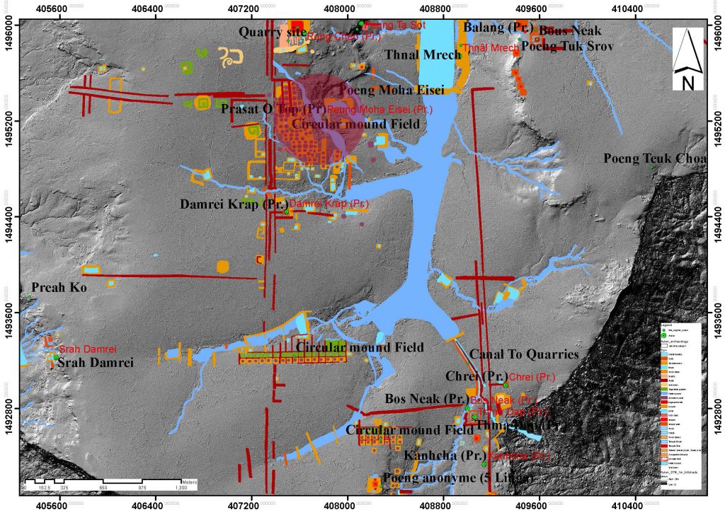
ចម្លាក់លើថ្មធម្មជាតិភាគច្រើននៅជុំវិញពើងឥសី និងស្រះទឹក មួយចំនួនមានប្រភពទឹកហូរកាត់ និងមួយចំនួនលិចទឹកនៅក្នុងរដូវវស្សា។ ចំណុចសំខាន់មួយទៀត នៅផ្នែកខាងលើស្រះទឹក និងពើងឥសីមានទួលមូលរត់ត្រង់ជាជួរ ដែលជាការរៀបសម្រាប់ពិធីសាសនាអ្វីមួយ ឬជាតំបន់ព្រាហ្មសម្រាប់គ្រប់គ្រងទឹក។ ចំណុចនេះត្រូវការទិន្នន័យបន្ថែម ដើម្បីបញ្ជាក់ពីតួនាទីទួលមូលរត់ជួរគ្នានេះបន្ថែមទៀត ត្បិតអីលោក Chevance (ក្រុមADF) បានធ្វើកំណាយម្តងហើយ តែមិនទាន់អាចសន្និដ្ឋានបានថាជាទីតាំងសម្រាប់អ្វីនោះទេ។ ដោយឡែកទួលរាងមូល ទំនប់ទប់ទឹក និងស្រះទឹក ឬបារាយណ៍លាយជាមួយប្រភពទឹកធម្មជាតិហូរកាត់បែបនេះ ព្រមទាំងស្ថិតនៅតំបន់ខ្ពស់ ក៏ប្រទះឃើញមាននៅឦសានបុរៈ(សំបូរព្រៃគុក)។
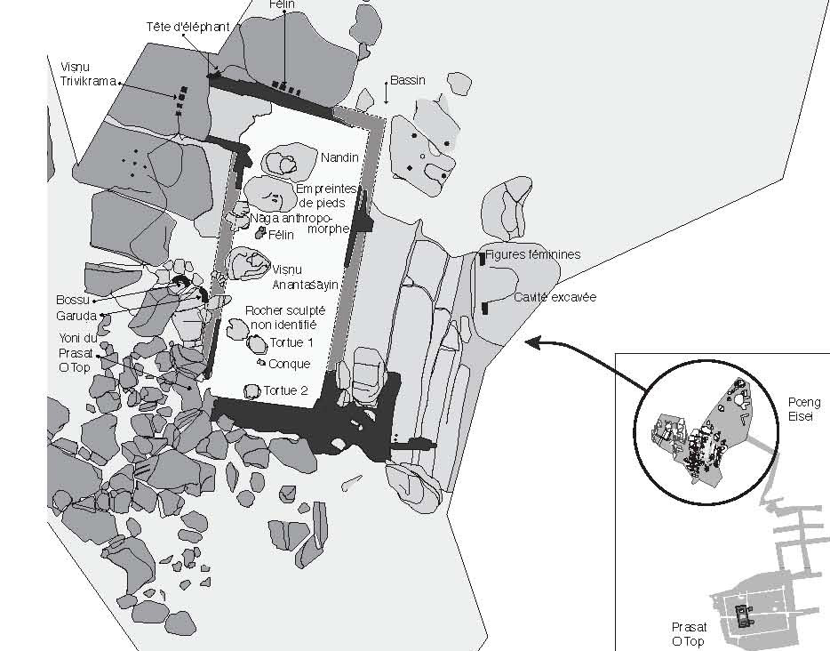
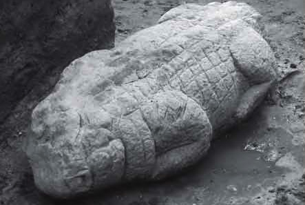
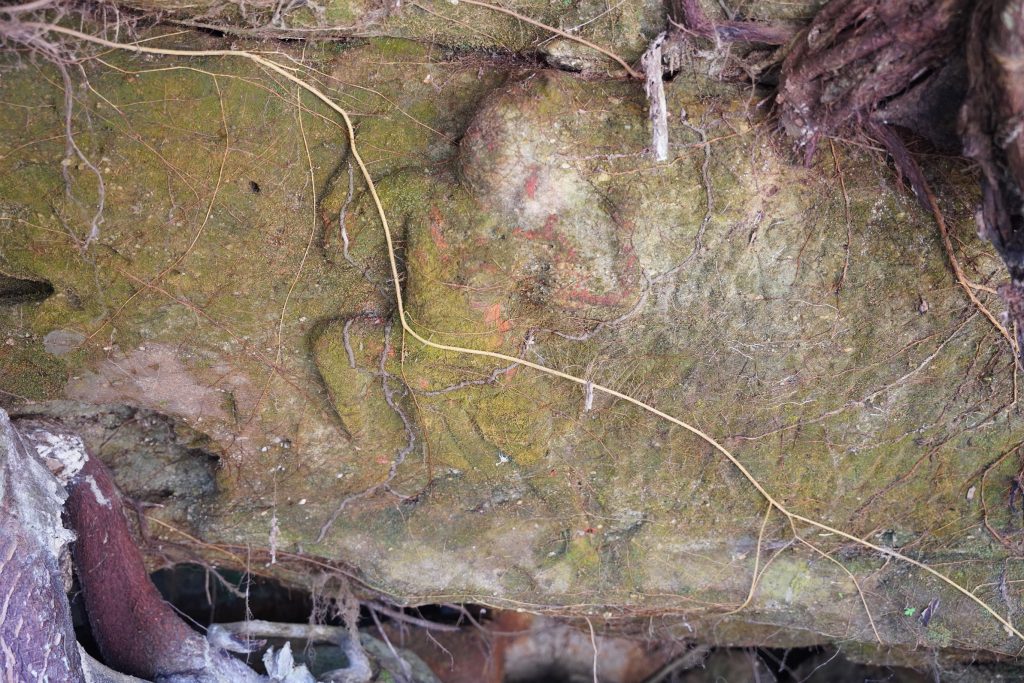
ចម្លាក់នៅពើងឥសីមានតួនាទីសំខាន់ផ្សេងមួយទៀត ដើម្បីភ្ជាប់ជាមួយការរៀបចំប្រភពទឹកពិសិដ្ឋ និងស្រះទឹកទាំងអស់នេះឡើង។ ចម្លាក់សំខាន់ៗទាំងនោះ មានចម្លាក់ព្រះវិស្ណុផ្ទំលើនាគ (Viṣṇu Anantaśāyin) មានអាយុកាលស.វទី៩ដល់ទី១១គ.ស ចម្លាក់ព្រះវិស្ណុយកកំណើតជាមនុស្សតឿ មានរៀបចំស្រះទឹកពីខឿនថ្មបាយក្រៀមភ្ជាប់ជាមួយថ្មធម្មជាតិ មានព្រះបាទព្រះសិវៈលើគោនន្ទិន សត្វអណ្តើក សត្វដំរី ក្បាលយក្ស ខ្លា ក្រពើ និងគ្រុឌ។
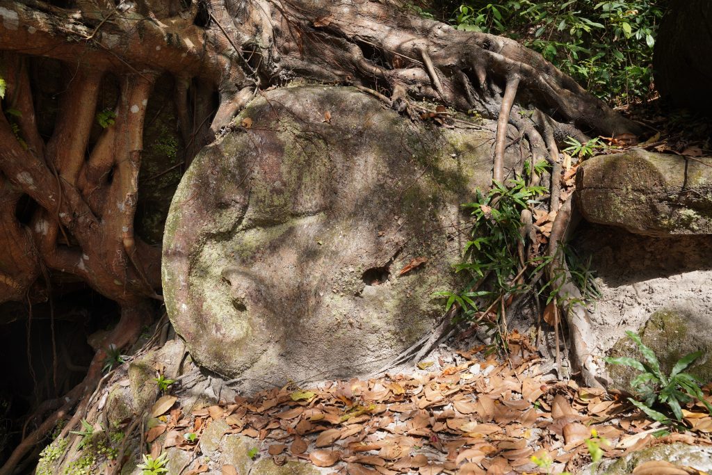
ចំណុចសំខាន់មួយទៀត យើងសង្កេតឃើញថា ពើងឥសីមានឆ្លាក់លើថ្មធម្មជាតិជារូបសត្វគ្រុឌ បំណែកនាគ អណ្តើក ក្រពើ បានឆ្លាក់នៅក្នុងទឹកស្រះជាមួយចម្លាក់ព្រះវិស្ណុផ្ទុំលើនាគ។ ពើងឥសីមានស្នាមកាត់ថ្ម ចាំងថ្ម ជញ្ជាំងផ្នែកខាងលើ និងខាងត្បូង និងស្រះដែលរៀបចំបន្សុតទឹកពិសិដ្ឋពីធម្មជាតិសម្រាប់យកធ្វើពិធីសាសនា។
ដូច្នេះការរៀបចំពើងឥសី មានប្រភពទឹកធម្មជាតិ មានស្រះទឹកភ្ជាប់ជាមួយថ្មភ្នំ ឬប្រភពទឹកធម្មជាតិ មានចម្លាក់ព្រះវិស្ណុផ្ទុំលើនាគផុសចេញកណ្តាលស្រះ និងចម្លាក់សត្វឬទេពមួយចំនួនដែលឆ្លាក់មិនទាន់រួច ឬក៏ជាបំណែកនៅក្នុងបាតស្រះ ប្រហែលជាការរៀបចំជាយ័ន្តឬពិធីសម្រាប់សាសនាតាមបែបខ្មែរលាយឥណ្ឌា ដែលទាក់ទងនឹងការបង្កើតលោកថ្មី រាជធានីថ្មី និងកសាងសំណង់ថ្មីៗ។
តើការរៀបចំចម្លាក់នៅពើងឥសី និងស្រះទឹកមានទំនាក់ទំនងអ្វីខ្លះជាមួយប្រាសាទរោងចិន បារាយណ៍ថ្នល់ម្រេច និងរាជវាំង? តាមការរៀបចំពើងឥសីនិងស្រះទឹកនេះឡើង គឺជាទំនៀមសាសនាខ្មែរលាយជាមួយឥណ្ឌា ដែលបន្តពីសម័យមុនអង្គរ រហូតប្រទះឃើញមានការរៀបចំដូចគ្នានឹងពើងឥសីដែរ នៅត្រពាំងខ្នាររាជធានីកោះកេររបស់ព្រះបាទជ័យវរ្ម័នទី៤ និងសម័យក្រោយៗទៀតជាបន្តបន្ទាប់៕
————————————
Function and structure of Peung Ey Sey at Kulen mountain
In the capital city of Mahendraparvata, Phnom Kulen have not only temples, water systems and quarries but also natural shelters and caves. Peung Ey Sey or Ey Sey cave is crucial for building the city. It has a water management system, reliefs on the rock and religious purposes. According to Stern, in 1938, there were some reliefs on the stone, pedestals, female deities, animal figures and reliefs depicting the stories. The reliefs on the cave and the pond suggest to us the concept of managing the natural water source to the religion. Significantly, it was the belief of sacred water in the reign of King Jayavarman II. The geology of the Peung Ey Sey, pond and its surrounding reliefs were essential for the capital city of Mahendraparvata. That is significantly about the cave, cave with female deities and pond from a religious point of view? What is the reason?
According to LiDar, the Peung Ey Sey, pond and the cave with water source are higher than the location of Baray and the royal palace. Especially, the area is the source of rainwater and the water from the ground. Mostly, the reliefs are surrounding the cave, and at the pond. Some of them have the water pass through, and some others submerge in the rainy season. t Furthermore, on the upper part of the pond and Peung Ey Sey has a range of mounts that were set probably for ceremonies or rituals to manage the water. This hypothesis might need more evidence. According to Chevance, the excavation for the mounds have been conducted, yet the conclusion remains unclear. However, a similar arrangement existed in Isanapura, Sambo Prei Kuk.
The reliefs at Peung Ey Sey have another function for connecting the secret water source to the pond. Those reliefs are reclining Vishnu from the 9th to 11th century, the relief of an incarnation of Vishu; Vamana, the arrange of laterite block to connect the natural stone, Shiva on Nandin, Turtle, Elephant, Demon head, Tiger, Crocodile and Garuda.
Also, the Peung Ey Sey has some carvings of Garuda, part of Naga, and Turtle were carved in the pond together with the statue of reclining Vishnu on Naga. The cave itself remains the traces of cutting the stone, and water in the pond was purifying use in religion. Therefore, the arrangement of Peung Ey Sey to have a source of natural water, the pond that connects to the rock or natural water source, the relief of reclining Vishnu in the middle of the pond, the figure of animals or unfinished deities, and the fragments on the bottom of the pond probably a Yantra or a combination of a Khmer and Indian ritual related to the creation of the universe, a new city and new construction. Is there any connection with the Rongchin temple, Thnal Mrech Baray, and the royal palace? Relatedly, the arrangement of the place was a continuous concept of the pre-Angkorian period. Similar examples appear in Trapang Khna at Koh Ker, the capital city of King Jayavarman IV and later periods.
អត្ថបទដើម៖ លោក ថូ ថុន


