

រលំ គឺជាពាក្យមួយក្នុងភាសាខ្មែរដែលយើងតែងដឹងមានន័យថា “ដួល ដេកទាំងស្រុង ទាំងជំហរ ឧទាហរណ៍ ដើមឈើរលំ សសររលំ” ។ ពាក្យនេះមានប្រើប្រាស់តាំងពីសម័យបុរាណមកម្ល៉េះ ប៉ុន្តែគេសរសេរដោយប្រើ “របាទ” ដាក់នៅលើអក្សរ “ល” និងអាចមានន័យផ្សេងមួយទៀត ដែលគេជួបនៅក្នុងសិលាចារឹកបុរាណខ្មែរយ៉ាងតិច ៩ ដូចជា ប្រាសាទអ្នកបួស ខេត្តព្រះវិហារ K.341 (ចន្ហ្វរ ល៌ំ ស្រេ វ្នុរ), សិលាចារឹកប្រាសាទព្រះក្សេត្រ ខេត្តឧត្តរមានជ័យ K.237 (ភូមិ ល៌ំ ស្លុត), សិលាចារឹកប្រាសាទអ្នកបួស ខេត្តព្រះវិហារ K.343 (ល៌ំ ហ្មះ ទឹក), K.720 (ល៌ំ អង្កាញ), K.229 (ល៌ំ ថ្បល អំវិល), K.190 (ល៌ំ ជ្វិក), K.158 (ល៌ំបញ្ជល), K.467 (ល៌ំ ទំនប្បបាក), K.257 (ល៌ំ ទ្យន) ។ លោក ឡុង សៀម ពន្យល់ថា “រលំ” (ល៌ំ) មានន័យថា “ដីបាក់ ឬច្រាំងបាក់” រីឯលោក កំ វណ្ណារ៉ា យល់ថា “រលំ” មានន័យថា “ទំនប់ទឹក ឬទំនប់ដែលគេដាក់បាំងទឹក”។ ពាក្យ “រលំ” ខ្មែរយើងបច្ចុប្បន្ន បានយកមកប្រើប្រាស់ហៅសម្គាល់ឈ្មោះស្ថាននាមជាច្រើន ហើយក្នុងនោះយើងនឹងលើកយកស្ថាននាមបុរាណដ្ឋានចំនួនពីរមកសិក្សា ពោល គឺ ប្រាសាទរលំ នៅតំបន់កោះកេរខេត្តព្រះវិហារ និងរលំស្រីស នៅខេត្តកំពង់ធំ។ តើហេតុដូចម្តេចបានគេហៅបុរាណដ្ឋានទាំងពីរនេះថាដូច្នេះ?
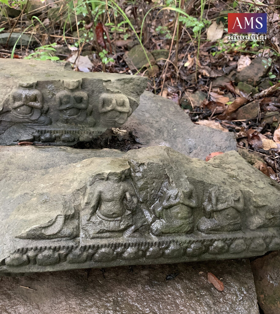
រលំស្រីស គឺជាឈ្មោះដែលអ្នកស្រុកហៅសំដៅលើព្រែកជីកបុរាណមួយ មានប្រវែងជាង ១០០ម៉ែត្រ ដែលមនុស្សបុរាណជីកបំបែកយកទឹកចេញពីស្ទឹងស្ទោង ត្រង់ចំណុចភូមិត្រពាំងព្រីង ឃុំសាគ្រាម ស្រុកប្រាសាទបល្ល័ង្ក ខេត្តកំពង់ធំ។ ព្រែកជីកបុរាណនេះ មានទទឹងប្រមាណ ១៥ម៉ែត្រ និងមានទំនប់ដីសងខាងប្រវែងប្រមាណ ១០ម៉ែត្រ។ នៅមិនឆ្ងាយពីព្រែកជីកបុរាណនេះ សម្បូណ៌ដោយគ្រឹះប្រាសាទចាស់ៗជាច្រើន ដូចជា ប្រាសាទគ្រឹះប្រាង្គ ប្រាសាទវត្តត្រពាំងព្រីង ប្រាសាទតាប្រាំង ប្រាសាទបង្កង តែជាអកុសលប្រាសាទទាំងអម្បាលម៉ានបានបាក់បែកបាត់រូបរាងស្ទើរទាំងស្រុងទៅហើយ។ ប្រភពព័ត៌មានពីអ្នកស្រុកប្រាប់មកយើងថា ពួកគាត់ក៏មិនដឹងច្បាស់ថា ហេតុអ្វីចាស់បុរាណហៅឈ្មោះព្រែកជីកនេះថា “រលំស្រីស” ដូច្នេះទេ ពោល គឺពួកគាត់បានឮតៗគ្នាពីមួយជំនាន់ទៅមួយជំនាន់ ហើយក៏មិនដឹងថាពាក្យ “រលំ” ដែលគេហៅនេះមានន័យថាដូចម្តេចឡើយ។ ប៉ុន្តែ អ្នកស្រុកស្ទើរគ្រប់គ្នាចងចាំរឿងព្រេងមួយដែលនិទានថា “កាលពីព្រេងនាយ មានគ្រួសារមួយប្រកបរបរជាអ្នកតម្បាញ ហើយក្នុងគ្រួសារនោះមានកូនពីរនាក់ (ស្រីម្នាក់ ប្រុសម្នាក់)។ កូនស្រីរបស់គាត់មានសម្រស់ស្អាតលើសនារីទាំងពួងនៅក្នុងភូមិ ហើយបុរសៗដែលនៅភូមិឆ្ងាយៗនិងភូមិជាមួយគ្នា តែងតែចូលស្តីដណ្តឹងនាងឥតស្រាកស្រាន្ត ប៉ុន្តែនាងក្រមុំមិនព្រមយកឡើយ។ ដ្បិត នាងក្រមុំបានចាប់ចិត្តស្រឡាញ់បងប្រុសបង្កើតរបស់នាង។ ក្តីស្នេហារវាងបងប្អូនបង្កើតនេះមិនអាចទៅរួចឡើយ ប្រសិនបើម្តាយឪពុករបស់ពួកគេដឹង ម្ល៉ោះហើយ អ្នកទាំងពីរក៏សម្រេចចិត្តពង្រត់គ្នាចេញពីផ្ទះ។ មុនមាន់រងាវ ពួកគេទាំងពីរបានពង្រត់គ្នាដោយជិះសេះសមួយ តែពេលសេះរត់នោះមានសត្វអន្ទង់ជាច្រើនតាមរុលពីក្រោយជើងសេះ រហូតធ្វើឱ្យបាក់ដីជាគំហុក។ គ្រានោះសេះពិបាករត់ពេកដោយសារដឹកមនុស្សធ្ងន់ ខាងប្រុសក៏សម្រេចច្រានខាងស្រីទម្លាក់ ហើយបានស្លាប់នៅទីនោះ ក៏កើតជាព្រែកជីកនេះទៅ។ ក្រោយមក គេក៏ហៅទីនោះថា “រលំស្រីស”។ អ្នកស្រុកខ្លះទៀតនិទានរឿងស្រដៀងគ្នានេះដែរ តែខុសត្រង់ថា តួអង្គស្រីជាម្តាយមីងរបស់ខាងប្រុស ស្រឡាញ់គ្នាតែត្រូវគេបំបែក ព្រោះខ្លាចបាប ក្រោយមកក៏ពង្រត់គ្នាដោយជិះសេះស ពេលនោះដោយសារបាបកម្មក៏ធរណីស្រូបស្លាប់បាត់ក្លាយជា “រលំ” ក៏ហៅទីនេះថា “រលំស្រីស”។
រឿងព្រេងទាំងពីរខាងលើនេះ ផ្តល់ពន្លឺជាច្រើនសម្រាប់យើងសាកល្បងពិចារណាអំពីឈ្មោះរបស់ព្រែកជីកបុរាណនេះ ប៉ុន្តែយើងក៏មិនអាចយកមកយោងទាំងស្រុងបានឡើយ។ យើងស្នើថា ការហៅឈ្មោះព្រែកជីកនេះថា “រលំស្រីស” ដូច្នេះ ទំនងមកពីមនុស្សជំនាន់មុនហៅសំដៅដល់ដីដែលបាក់ច្រាំង ឬទំនប់ដែលនៅសងខាងព្រែកជីកបុរាណថា “រលំ” ហើយពាក្យ “ស្រីស” ខាងចុងអាចគេសំដៅដល់រូបទេពស្រីណាមួយដែលគេឃើញនៅប្រាសាទគ្រឹះប្រាង្គស្ថិតនៅជាប់មាត់ព្រែកជីក។ ដ្បិត តាមប្រភពពីអ្នកស្រុកបានរៀបរាប់ថា ពីមុនមកនៅប្រាសាទគ្រឹះប្រាង្គគេធ្លាប់ឃើញរូបចម្លាក់ទេពស្រីមួយអង្គធ្វើអំពីថ្មភក់ ហើយបើនៅកណ្តាលព្រែកជីកចាស់ៗនិទានថាមានកីតម្បាញមួយធ្វើអំពីថ្ម។ យើងពុំដឹងថាកីតម្បាញធ្វើអំពីថ្មដែលគាត់រៀបរាប់នោះជាអ្វីឱ្យ ប្រាកដឡើយ ប៉ុន្តែការហៅឈ្មោះ “ស្រីស” សំដៅដល់រូបទេពស្រីដែលយើងគិតអាចសមហេតុផល ដ្បិតនៅក្នុងសង្គមខ្មែរគេនិយមហៅទេពស្រីនៃព្រហ្មញ្ញសាសនាថា “ស្រីខ្មៅ” ដែលសំដៅដល់ព្រះនាងទុគ៌ា (មហេសីរបស់ព្រះឥសូរ) ដូច្នោះ “ស្រីស” ក៏អាចចេញពីរូបទេពស្រីណាមួយដូចគ្នា។ ម្យ៉ាងវិញទៀត ការសន្និដ្ឋានយ៉ាងស្តួចស្តើងមួយទៀតគឺ គេអាចហៅសំដៅដល់តួអង្គស្រីក្នុងរឿងព្រេង។
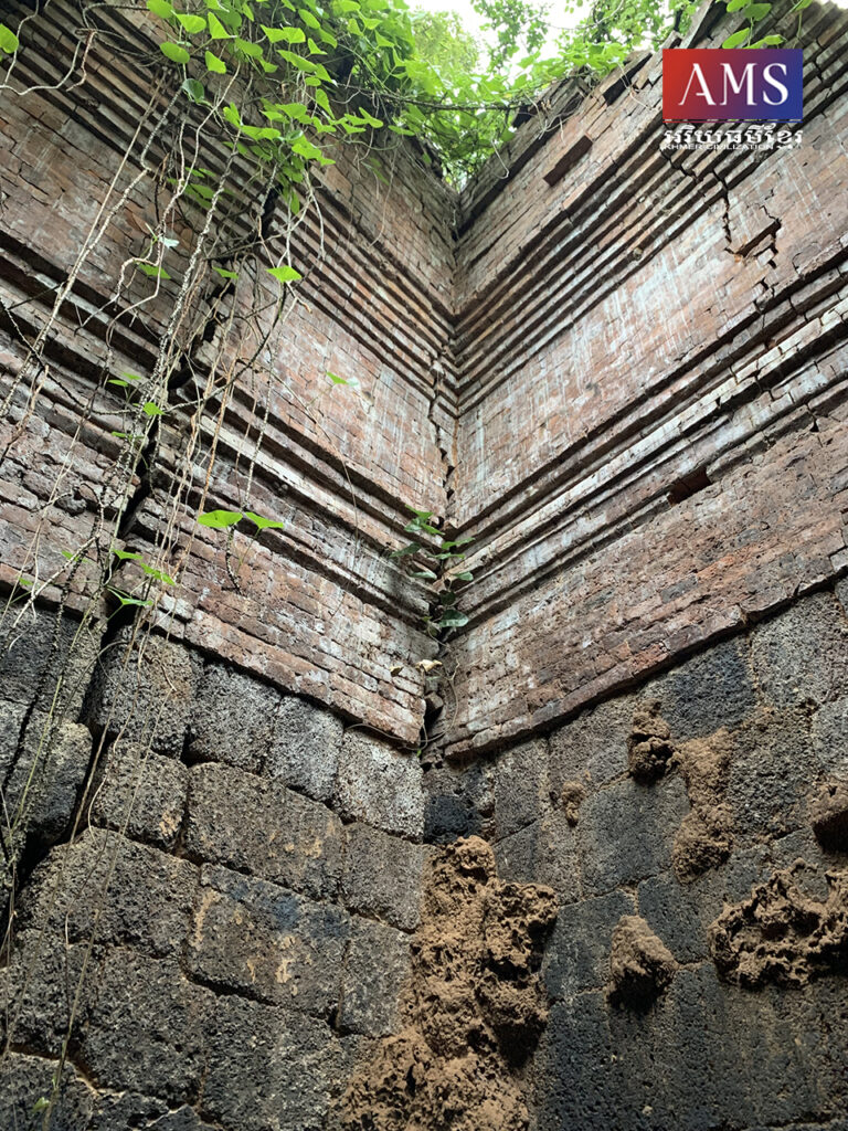
ដោយឡែក ប្រាសាទរលំ គឺជាប្រាសាទមួយដែលស្ថិតនៅក្នុងតំបន់ប្រាសាទកោះកេរ ក្នុងស្រុកគូលែន ខេត្តព្រះវិហារ។ ប្រាសាទនេះ មានទីតាំងស្ថិតនៅភាគពាយព្យប្រាសាទធំ ដែលសាងឡើងអំពីថ្មបាយក្រៀមពាក់កណ្តាលនិងឥដ្ឋឥដ្ឋពាក់កណ្តាល និងមានកំពែងព័ទ្ធជុំវិញធ្វើអំពីថ្មបាយក្រៀម ហើយទំនងសាងនៅស.វ.ទី១០ ក្នុងរជ្ជកាលព្រះបាទជ័យវរ្ម័នទី៤ ដំណាលគ្នាជាមួយប្រាសាទដទៃទៀតនៅក្នុងតំបន់កោះកេរ។ លោក ហួន យ៉ាវ ធ្លាប់បានសាកសួរអ្នកស្រុកដែលរស់នៅតំបន់កោះកេរអំពីឈ្មោះប្រាសាទនេះដែរ តែអ្នកស្រុកបានឆ្លើយថា ការហៅដូច្នេះទំនងមកពីប្រាសាទនេះបានបាក់រលំ។ ប្រសិនបើយើងមើលតែតួប៉មកណ្តាលរបស់ប្រាសាទយើងឃើញថា ប្រាសាទនេះមានឥដ្ឋធ្លាក់ជ្រុះមកក្រោមតិចតួចប៉ុណ្ណោះ ដូច្នេះហើយវាមិនអាចឆ្លើយតបស្របគ្នាជាមួយនិយមន័យ “រលំ” ដែលខ្មែរយើងប្រើប្រាស់សព្វថ្ងៃនេះបានទេ ដ្បិតទាល់តែដួលដេកទាំងស្រុង ទើបគេហៅថា “រលំ”។ យើងស្នើថា ការហៅប្រាសាទនេះថា “រលំ” ទំនងមកពីទីតាំងប្រាសាទនេះស្ថិតនៅក្បែរទំនប់ទឹក ដ្បិតភស្តុតាងផ្នែកបុរាណវិទ្យាបង្ហាញឱ្យយើងឃើញថា ទីតាំងប្រាសាទស្ថិតនៅខាងចុងទំនប់ដីនៅតំបន់កោះកេរ (ពាយព្យប្រាសាទធំ)។ សូមបញ្ជាក់ថា នៅតំបន់កោះកេរមានទំនប់សំខាន់ៗចំនួនបី គឺទំនប់ខាងលិចប្រាសាទធំ ទំនប់ខាងជើងប្រាសាទធំ និងទំបន់ស្ថិតនៅផ្លូវបុរាណភ្ជាប់ពីក្រុងទៅកាន់ផ្លូវបុរាណដែលភ្ជាប់ពីតំបន់អង្គរទៅវត្តភូ។ ទំនប់ទាំងអស់មានប្រឡាយទឹអមសងខាង កម្ពស់ ៧ឬ៨ម៉ែត្រ ហើយទំនប់នេះមានតួនាទីសំខាន់ពីរគឺ សម្រាប់ទប់ទឹក និងជាផ្លូវចូលមកកាន់ក្រុង។ ទំនប់នីមួយៗមានប្រវែង ៤-៥គ.ម. ហើយទំនងគេកសាងស្ពានឈើនៅកន្លែងទឹកឆ្លងកាត់។
ជារួមមក ស្ថាននាមបុរាណដ្ឋានទាំងពីរដែលមានឈ្មោះ “រលំ” ដូចបានរៀបរាប់ខាងលើនេះ ទំនងកើតឡើង និងមនុស្សជំនាន់មុនហៅសំដៅដល់ដីច្រាំងបាក់ ឬទំនប់ទឹក ដ្បិតន័យម្យ៉ាងទៀតរបស់ពាក្យ “រលំ” ដែលខ្មែរយើងប្រើតាំងពីបុរាណកាលមកមានន័យថា “ដីច្រាំងបាក់ និងទំនប់ទឹក” ពោល គឺស្ថាននាមទាំងពីរពុំមែនសំដៅលើការដួលរលំនោះឡើយ។
———————————————————-,
Two toponymies historical sites with named “Rlaṃ”
Rlaṃ is a word in Khmer that we always know means “fall over, completely collapsed, for example, a fallen tree, a fallen column.” The word has been used since ancient times, but it is written with “របាត” over the letter “ល” and may have other meanings found in at least nine ancient Khmer inscriptions, such as Neak Bous Temple, Preah Vihear Province. K.341 (Canhvar Rlaṃ Sre Vnur), Inscription of Preah Kṣetra temple, Oddar Meanchey province K.237 (Bhūmi Rlaṃ Slut), Inscription of Neak Bous temple, Preah Vihear province K.343 (Rlaṃ Hmaḥ Dik), K.720 (Rlaṃ Aṅgañ), K.229 (Rlaṃ Thpal Aṃvil), K.190(Rlaṃ Javik), K.158 (Rlaṃ pañjl ), K.467 (Rlaṃ Daṃnap pāk), K.257 (Rlaṃ Dyan). Mr. Long Siem explained that “Rlaṃ” means “landslide or bank collapse”, while Mr. Kam Vannara understands that “Rlaṃ” means “dam or dam that is blocked a water.” The Khmer word “Rlaṃ” is now used to denote the toponymies and also will take the toponymy of two historical sites to study, namely the Rlaṃ temple in Koh Ker, Preah Vihear province and Rlaṃ Srei Sor in Kampong Thom province. Why are these two historical sites so-called?
Rlaṃ Srei Sor is the name given by the locals to an ancient canal more than 100 meters long, which was dug to separate the water from Stung Stong at Trapeang Pring village, Sakram commune, Prasat Balank district, Kampong Thom province. This ancient canal is about 15 meters wide and has a dam on both sides about 10 meters long. According to the locals tell us that they also do not know exactly why the ancients called this canal “Rlaṃ Srei Sor”, that is, they have heard from a generation to another and did not know what the word “Rlaṃ” means.
However, almost all locals remember the legends associated with the name “Rlaṃ Srei Sor”. Moreover, we realize that the name of this canal is called “Rlaṃ”, therefore it is likely that earlier generations referred to the landslide or dam on either side of the ancient canal as “Rlaṃ” and the word “Srei Sor” refers to any female goddess seen in the Prasat Kruah nearby this canal. According to local sources, they had seen a statue of a goddess that was made of sandstone, and in the middle of the canal, there was a weaver made of stone. We definitely do not know what the stone weaver they described was, but the name “Srei Sor” refers to a goddess who we think may be reasonable, as in Cambodian society it is popularly called the goddess of Brahmanism “Srei Khmao” refers to goddess Durga (wife of Shiva), so “Sre Sor” can also come from any female goddess as well. On the other hand, another consideration is that one can refer to a female character in a legend.
Besides, Prasat Rolum is located in the Koh Ker temple complex in Kulen district, Preah Vihear province. It was built of sandstones and bricks and has a wall made of laterite, probably built in the 10th century during the reign of Jayavarman IV simultaneously with other temples in the Koh Ker area. According to the locals in the Koh Ker area said that the call was likely due to the temple collapsing. If we see only at the central tower of the temple, we recognize that this temple has only a few bricks falling down, so it can not respond in accordance with the definition of “Rlaṃ” that we use today.
We suggest that the call of the temple “Rlaṃ” is likely due to its location near the dam, as archaeological evidence indicated that the site was located at the end of a dam on Koh Ker (northwest of the main temple). Please note that in the Koh Ker area, there are three main dams: the west dam of Prasat Thom, the northern dam of Prasat Thom, and the dam on the ancient road connecting the city to the ancient road that connects Angkor to Wat Phu. All dams have canals 7 or 8 meters high on each side, and this dam has two main functions: to reservoir and as a gateway to the city. Each dam is 4-5 km long and it is likely that a wooden bridge was built at the water crossing.
Overall the two toponymies historical sites named “Rlaṃ” as mentioned above are likely to occur and the previous generation referred to the landslide or dam because the other meaning of the word “Rlaṃ” that Khmer people use since ancient times means “landslides and dam”, that is, the two names do not refer to the fall or collapse.
អត្ថបទដោយ៖ លោក ម៉ង់ វ៉ាលី


